Saturday, June 22, 2013

Windy Ridge and West Fork Fire join to become the West Fork Complex Fire June 20, 2013

We felt pretty safe and decided to remain in South Fork for another night.  We got a spot along the Rio Grand at the South Fork RV Park.  It was probably close to about noon when the fires kicked it up a notch and before the night was over grew into one huge fire versus 2 smaller fires. 


Just at sunset we spoke to a couple from Oklahoma that had attended a town meeting. They told us that everyone had been assured that South Fork was safe and not to worry.  So we went to bed intending to head out in the morning for La Veta, our next camping spot.
 
At 1:30 am we were awaken to someone pounding on our door.  We were told we needed to get ourselves ready to evacuate. The fire had traveled seven miles in the last few hours and the town of South Fork was in imminent danger. Since we had just pulled in and planned to stay only the one night we had very little to do to get ready to pull out.  I really felt awful for most of the others in the RV park.  We had wondered around during the day talking with people so we knew that most of the people in this particular park had been there for at least a month and most were set up to spend the summer. Awnings were pulled out, tables and chairs set up for morning coffee time, clothes lines were hung, covers on tires, and planters with everything from flowers to herbs were abundant at almost every RV spot. To top it off I think Jim and I were by far the youngest couple in the park. So once we had our sewer, water and electric disconnected we took a pass through the park offering to help others.  I have to say I was very impressed with how smoothly and quickly it went.  Within the hour everyone was buttoned up and ready to roll. 
 
We watched the news tonight and the fire is still growing and crews are standing by to try and save South Fork. My prayers are with them.
 

Boondocking at West Fork in the San Jaun National Forest June 19, 2013

We headed on down the road first thing in the morning with plans reach West Fork camping area by night fall.  We traveled through Durango but elected not to stop because the traffic seemed pretty heavy.  At Pagosa Springs we stopped, found a coffee shop and had a latte. Then spent a couple hours wandering around town looking in gift shops and antique stores before hitting the road again. Just out of Pagosa Springs we got our first glimpse of smoke.

 
Just as we were trying to figure out if the fire was near the campground we came to a wide spot on the road where a dozen or more cars were pulled off taking pictures. 


We of course pulled over for Jim to get pictures and someone I spoke with pointed out a sign board that had been set up with information about the fire's location, we checked it out and learned that West Fork Camping area was still open so we headed on up the hill.
 
What a hill it turned out to be.  When we finally reached the summit we were at 10,850 feet.  The MH it turns out does not like climbing that steep of a grade. For the first time ever we overheated the poor thing. We ended up pulling off the road three times to let the engine cool down. 
 
 
Jim was so busy taking pictures of the smoke that he only got this one shot of the hill we climbed.
If you are able to enlarge this picture you can just see the road where we originally started our trip up. The road runs just on the left side of the clearing that you see in the little valley.


As we approached the summit we became aware the we were actually between two fires.  The smaller of the two fires on our right was the Windy Ridge fire. 


The larger fire on our right was called the West Fork fire.
 
 
The closer we got to our destination the clearer it became that we would not be camping at West Fork, regardless of what the information board said.


At this point on our trip I was not feeling good about driving through the area, let alone stopping to camp, so we just kept going on down the road.
 
 
Through the smoke

and into the town of South Fork.
 
We stayed at a rest area at the far end of South Fork and watched a sunset made beautiful by the smoke in the air.


Cortez, Colorado June 18,2013

When we came down from Mesa Verde we decided we should probably run back to Cortez and fuel up. After getting fuel we decided we should take advantage of Walmart and get some groceries. By the time we had finished with all our stops around town it was getting late in the day so we found a quiet pull off  and just kicked back, read a book, and relaxed.

 
Here is Zoe kicking back taking it easy.
 

Thursday, June 20, 2013

Through the Ute Reservation and onto Mesa Verde June 16 and 17, 2013

We left Four Corners fairly early and the next section of road took us through the Ute Reservation.

We were headed towards the mountains of Colorado and Mesa Verde in hopes of seeing more ancient Indian dwellings

The road into Mesa Verde climbs rather steeply from about 5,000 feet to its highest point of 8,500 feet

 
Jim took this picture so I could see how high I was climbing. I wasn't doing much gawking around.  My eyes were glued to the steep winding road I was navigating.  We went about five miles up in the MH and then left it at our camping site for the night and took the Jeep on up to the top.  Again I was thankful for having gotten Jim his National Park Senior pass. No charge for getting into the park and the camping spot was only $10.00. What a great deal the pass has been, to date it has saved us just over $200.00

 
Here we are almost to the top.


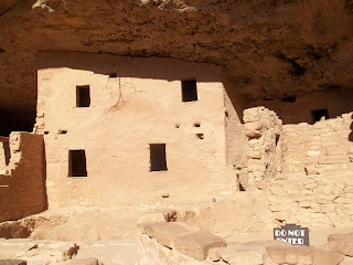
 Although there are three cliff houses on Mesa Verde this is the only on we visited. The other two required strenuous climbs. On required a climb up a 32 foot high ladder.  I am sure you all know by now you won't find me doing that.


To reach the cliff house we visited we had to walk down a trail that dropped 100 feet in elevation in less the a quarter mile.  The walk down was like going from one climate to another. Up on top it was hot, dry, and windy.  As we approached the halfway mark we began to notice  the temperature dropping and the brush around us was greener.  The closer we got to the bottom the more the temperature dropped and we began to fell moisture in the air and I could, for the first time in over a month, smell damp earth.

 
Archeologists are actively working this, so while we got to go right up to it, we weren't able to enter the rooms.

 I have to mention again, I just cannot imagine what it took to build these places.  This cliff house is called the Spruce Tree House and is over 900 years old.


 There are several areas similar to the one pictured here. They were originally underground but have been opened up by the archeologists.


The two pictures above are of the one room that still remains unopened. The room is probably eight feet deep and you have to keep in mind, this was dug out by hand and then lined with stone and mortar. Pretty amazing!

One the way back down we stopped at several pull offs. This pull off had this lonely dead tree just hanging on the side off the cliff.

 
If you look closely you can just make out the original road bed along the side of this steep hill. It has now been replaced by a tunnel through the mountain.
 
 
I of course had to have one picture of the desert flowers.


Here we are headed back down Mesa Verde.
 
Next planned stop will be just east of Pagosa Springs, Colorado were we will spend several days at West Fork dry camping (for free) in the San Juan National Forest.


Our trip through the Navajo Nation and past Four Corners

As you enter the Navajo Nation you are required to get a day permit for hiking and a permit if you will be in the Nation over night.  Not knowing how long we would be we opted to get an over night permit, which allows you to pretty much stop anywhere there is room and spend the night.

Our trip through the Navajo land was pretty awesome.  I can't get over how a place can be so desolate and beautiful at the same time. 
The beginning of the road that will take us through the Navajo Nation and on to four corners.


I love all the colors.

Seems like you can see forever.


                      This is called elephant feet Monument. It really does look like elephant feet.

This area was particularly colorful.

More of the same, but I haven't gotten over being in awe of the stark beauty.

More beautiful rock formations and they are red.

Clouds have been building on and off all day.  Looks like these clouds are actually producing some rain.


Well we had about a dozen drops of rain come down on us and now the wind has picked up and is going to sprinkle some dirt on top of the rain.


Visibility up ahead seemed to be getting a little questionable so I decided I would pull over.


                                                             Monument Valley


Another very colorful view at Monument Valley


We arrived late at Four Corners and decided the sky was prettier then the monument.


Since it was a pretty view and quiet at Four Corners we decided to remain just outside their gate for the night.  It didn't stay quiet for long.  It seems we had chosen a very popular spot for overnight parking.  We were joined by a couple other motor homes, a car full of young people, and finally a semi that left his engine running all night.